Hiking Guide
 Hiking Guide on the Lake Arrowhead Ranger District Trail System. An Adventure Pass is required to park at most trail heads. They are available in the Chamber Visitor Center, exceptions are noted.
Right Click on Image, Select “Open Image in a New Tab” or “Save As…” to Print
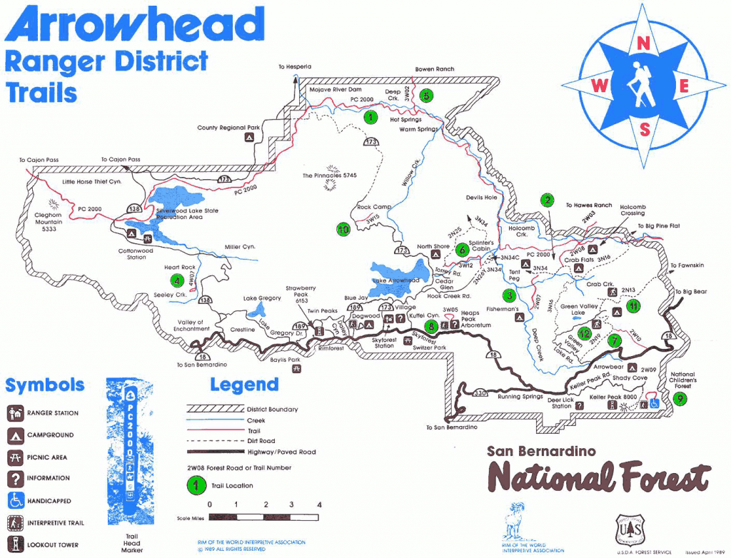
WILL ABELL MEMORIAL TRAIL at ARROWHEAD RIDGE #No Marked Number
- 2 mile loop, moderate
- The starting point for the Will Abell Memorial Trail can be found at the parking lot along Grass Valley Road, just 0.7mi north of the junction with CA-189.
- Dogs allowed on leash.
- Arrive early for parking.
- The first mile is a gentle climb up, while the second half is mostly downhill back to the entrance. Bikes are not permitted on this trail.
NATURE LOOP in LAKE GREGORY REGIONAL PARK #No Marked Number
- 2.5 mile loop, easy walk
- This lakeside trail begins from the back of the South Beach Parking area in Lake Gregory Regional Park.
- From Highway 18, take Lake Gregory Drive to San Moritz Drive. Turn Right on San Moritz and look for the Parking area on your left.
- This is a great hike for dogs.
SEELEY CREEK TRAIL – 4W07 (Heart Rock) #4
- 1 mile each way, easy walk in Crestline
- To reach this short trail turn left on FS Road 2N03 at the entrance to Camp Seeley on Highway 138.
- Proceed ¼ mile to the trailhead, marked “Heart Rock 4W07”.
- This easy hike follows Seeley Creek to an overlook called “Heart Rock” which marks the trail’s end.
- The gentle grade of this trail makes it an excellent walk for all ages. The Adventure Pass is not required at this trailhead.
DEEP CREEK/SPLINTERS CABIN – PACIFIC CREST TRAIL ACCESS POINT #6
Dirt road closed to vehicle traffic at the gate temporarily. Hiking in is allowed.
- Moderately difficult Hikes in Cedar Glen
- Located on Hook Creek Rd. in Cedar Glen (off Hwy. 173) Drive to end of Hook Creek Rd.
- The road becomes a forest service dirt road. Stay left when the road forks.
- Soon you will see an open gate on the right leading to a ½ mile drive to the picnic & restroom area.
- An Adventure Pass is required to park at the trailhead. Follow the signs to Deep Creek and the Pacific Crest Trail.
- The Pacific Crest Trail stretches from the Mexican border to the Canadian border so you can choose your own distance on this one.
NORTH SHORE NATIONAL RECREATIONAL TRAIL – 3W12 & 2N25 #by No. 6
- 1.7 miles each way, moderately difficult
- Begins near site #11 at the North Shore Campground in Lake Arrowhead
- (2 ways to reach the hiking trail)
- To Reach trail #2N25:
- Take Hospital Rd. (off Hwy. 173) When you drive up Hospital Rd. you will see a road on your left & a North Shore Campground sign.
- Park along the road outside the campground. Proceed to site #11 where you will see the North Shore Recreation Trail sign
- To Reach Trail #3W12:
- Turn east on Torrey Road opposite the Lake Arrowhead Marina (on Hwy. 173)
- Turn at first left and follow the dirt road 1/2 mile to where you reach the trail head on the east (right) side of 2N25.
HEAPS PEAK ARBORETUM TRAIL #8
- 1 mile loop, easy walk in Sky Forest
- This interpretive trail is located 2 miles east of Sky Forest on Highway 18.
- The trail is an easy walk for all ages that takes you through a self-guided tour with 25 points of interest about native plants and wildlife.
CHILDREN’S FOREST EXPLORATION TRAIL #9 - TEMPORARILY CLOSED
- 4.5 miles each way, moderately difficult in Running Springs (12% grade)
- This trail will take you into some of the San Bernardino Mountains’ most beautiful country. This non-motorized trail crossing the 3,400 acre National Children’s Forest is open for use year round & is family-friendly.
- The trail starts on Keller Peak Road (first right after Deer Lick Fire Station, traveling toward Big Bear) in Running Springs on Hwy. 18. The trailhead is on the right a little way inside the gate. (The gate is locked from the first snowfall until the road is completely thawed and cleared of obstructions in the spring.)
TRAIL OF THE PHOENIX at the CHILDREN’S FOREST #9
- 0.5 mile loop, easy walk
- This paved nature trail begins near the top of Keller peak Road in Running Springs.
THE PINNACLES 5745 #Just Past No. 10
- 3.5 mile each way, this is a moderate to difficult hike
- To get to this trail head take HWY 173 down to the shooting range.
- When you see the shooting range sign on your left , turn left on the left hand side of the shooting range (on the same side of the street) you should see the trail head post.
- There is limited parking. The views from this hike can be quite spectacular so bring a camera plus we recommend plenty of water.
- For a printable copy of the Lake Arrowhead trails hiking guide click here
Leadership Circle